Medium-scale farms in Sub-Saharan Africa
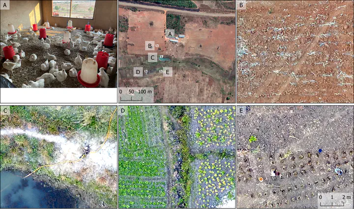 The multiple features of a medium-scale farm in Mozambique (top middle). Panels illustrate poultry barn (A), signs of mechanized land management (B), access to a water reservoir and irrigation equipment (C), diverse crop portfolio including vegetables (D), and access to on-farm labor (E). Overview image from August 2021 provided through Maxar Technologies via Google Earth, photograph taken by Cristina Chiarella, aerial imagery in panels B-E from drone acquisition in November 2021.
Current development discourses highlight the transformative potential of emerging medium-scale farms (MSF) in rural Sub-Saharan Africa. MSF, often defined as farming operations with land holdings of 5-100 ha, have been linked to increases in land and labor productivity, including through increased use of capital, inputs, and mechanization, as well as crop diversification. Additional spillovers on neighboring small-scale farms comprise learning and cost effects, changing land tenure security, as well as broader changes in labor markets, agricultural production, and rural development. The contexts in which MSF emerge remain poorly understood, though improved accessibility conditions, land tenure regulations, and economic development may be supporting factors. The emergence of MSF may accelerate forest loss through direct deforestation, in particular when MSF produce commodities with high price elasticity of demand, or through indirect pathways, e.g., smallholder displacement. Our current knowledge of the locations, rates, and conditions of MSF emergence as well as their contribution to deforestation is, however, limited. The overarching objective of this project is to unravel where, at which rates, and under which circumstances MSF emerge, and to assess their contribution to recent deforestation. This objective will be pursued by 1) using EO and deep learning to map individual fields at very high spatial resolution in selected countries and for two points in time, 2) estimating farm size from EO-based field delineations to reveal hotspots of MSF emergence, and 3) integrating these data with deforestation maps to analyze the contribution of MSF to recent deforestation. We selected Mozambique as an initial target country due to the high heterogeneity of the regional agricultural systems, the documented emergence of MSF, and widespread forest cover loss. We are building on a dense network of collaborating researchers and institutions, and a wealth of readily available reference data and in-situ knowledge of the processes at play. The project will provide the first large-scale, spatially detailed, and temporally precise picture of MSF emergence, which is a crucial contemporary dynamic in rural Sub-Saharan Africa expected to have deep consequences on land use, farming, rural development, deforestation, and other sustainability concerns.
Project outcomes
Datasets:
Rufin, P., Meyfroidt, P. (2024). Satellite-derived crop field boundaries in heterogeneous smallholder-dominated regions in the North of Mozambique. https://doi.org/10.5281/zenodo.11488975
Scientific papers:
Rufin, P., Meyfroidt, P., Akinyemi, F. O., Estes, L., Ibrahim, E. S., Jain, M., Kerner, H., Lisboa, S. N., Lobell, D., Nakalembe, C., Persello, C., Picoli, M. C. A., Ribeiro, N., Sitoe, A. A., Waha, K., & Wang, S. (2025). To enhance sustainable development goal research, open up commercial satellite image archives. Proceedings of the National Academy of Sciences, 122(7).
Meyfroidt, P., Abeygunawardane, D., Baumann, M., Bey, A., Buchadas, A., Chiarella, C., Junquera, V., Kronenburg García, A., Kuemmerle, T., le Polain de Waroux, Y., Oliveira, E., Picoli, M., Qin, S., Rodríguez García, V., Rufin, P. (2024). Explaining the emergence of land-use frontiers. Royal Society Open Science, 11(7), 240295. https://doi.org/10.1098/rsos.240295
Rufin, P., Wang, S., Nogueira Lisboa, S., Hemmerling, J., Tulbure, M. G., Meyfroidt, P. (2024) Taking it further: leveraging pseudo labels for field delineation across label-scarce smallholder regions. International Journal of Applied Earth Observation and Geoinformation, 134, 104149 https://doi.org/10.1016/j.jag.2024.104149
Chiarella, C., Rufin, P., Abeygunawardane, D., Bey, A., Lisboa, S. N., Zavale, H., Meyfroidt, P. (2024) Impacts of large-scale forestry investments on neighboring small-scale agriculture in northern Mozambique. Land Use Policy, 145, 107251. https://doi.org/10.1016/j.landusepol.2024.107251
Pratzer, M., Meyfroidt, P., Antongiovanni, M., Aragon, R., Baldi, G., Czaplicki Cabezas, S., De La Vega-Leinert, C. A., Dhyani, S., Diepart, J.-C., Fernandez, P. D., Garnett, S. T., Gavier Pizarro, G. I., Kalam, T., Koulgi, P., Le Polain De Waroux, Y., Marinaro, S., Mastrangelo, M., Mueller, D., Mueller, R., …, Rufin, P., …, Kuemmerle, T. (2024). An actor-centered, scalable land system typology for addressing biodiversity loss in the world’s tropical dry woodlands. Global Environmental Change, 86, 102849. https://doi.org/10.1016/j.gloenvcha.2024.102849
Jänicke, C., Wesemeyer, M., Chiarella, C., Lakes, T., Levers, C., Meyfroidt, P., Müller, D., Pratzer, M., & Rufin, P. (2024). Can we estimate farm size from field size? An empirical investigation of the field size to farm size relationship. Agricultural Systems, 220, 104088. https://doi.org/10.1016/j.agsy.2024.104088
Conference contributions:
Rufin, P., Thomas, L.-F., Lisboa, S.N., Ribeiro, N., Sitoe, A., Hostert, P., Meyfroidt, P. (2024): National-level crop field delineation in Sub-Saharan Africa using deep learning and Earth observation. Global Land Program Open Science Meeting. Oaxaca, Mexico.
Rufin, P., Thomas, L.-F., Lisboa, S.N., Ribeiro, N., Sitoe, A., Hostert, P., Meyfroidt, P. (2024): National-level crop field delineation in Mozambique using 1.5 m resolution SPOT data and transfer learning with pseudo labels. ESA EO4Africa Symposium. Frascati, Italy.
Rufin, P. (2024): Leveraging Earth Observation for characterizing heterogeneous farming systems in Sub-Saharan Africa. IAMO Forum. Halle, Germany
Rufin & Meyfroidt (2023): Understanding the Role of Medium-Scale Farms as Drivers of Deforestation in Sub-Saharan Africa based on Earth Observation and Deep Learning. Conference on Interdisciplinary and Transdisciplinary Research for Sustainable Development. Louvain-La-Neuve, Belgium.
Rufin, P., Meyfroidt, P. (2023): Transfer learning for smallholder field delineation and field size estimation in Sub-Saharan Africa. Tropentag. Berlin, Germany.
Akinyemi, F.O., Rufin, P., Ibrahim, E.S., Hostert, P., Ogunsumi, L.O, Egbe-Tokun, O.A., Ifejika Speranza, C. (2023): Mapping heterogeneous smallholder maize-cassava systems in southwest Nigeria based on Sentinel-1 and Sentinel-2 time series. Tropentag. Berlin, Germany.
Patrick Meyfroidt
Professor of Land Systems and Sustainability Science
My research focuses on how land systems can contribute to sustainability.