Paper on national-scale field delineation in smallholder landscapes of Mozambique
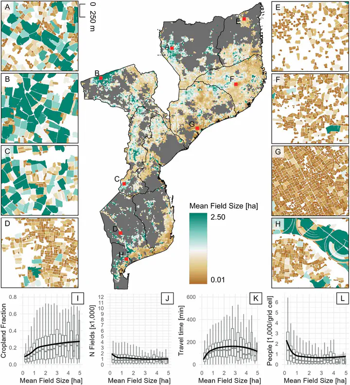
Mapping ~17 million individual fields across Mozambique allowed new insights into the spatial distribution of agriculture, field size and linkages between agriculture and forest cover change.
Smallholder farms are strongholds of global food production and provide livelihoods to rural populations across the globe. Surprisingly, fundamental properties of smallholder systems remain only weakly understood, which hampers the design of sustainability-centered policies and aid interventions. We delineated 17 million individual agricultural fields from very-high resolution satellite imagery (1.5) at the national level for Mozambique (covering ~800,000 km²). Our proposed workflow has minimum reference data requirements due to the use of pseudo-labels developed in a prior study and is therefore transferable across regions, providing a stepping-stone for better understanding smallholder farming systems.
The resulting data yielded unique insights into the spatial distribution of active cropland and field size showing, amongst others, that half of the fields in Mozambique are smaller than 0.2 ha. We identified linkages between field size and socio-economic indicators such as accessibility and population density. Moreover, we found increased rates of forest cover loss where field sizes were larger, pointing to diversity of actors associated with ecological trade-offs related to agriculture. These results suggest that field size is a relevant indicator relating to socio-economic and environmental outcomes of agriculture (e.g., food production, livelihoods, deforestation, biodiversity), as well as their trade-offs.
Read the full paper here!