Mapping large-scale tree plantation expansion and land use change trajectories in Northern Mozambique

This blog post is based on Bey et al. 2021 and this Twitter thread.
In this study we present a remote sensing technique to map tree plantations with high accuracy in a challenging context (Miombo dry forests, little spectral & phenological differences between plantations and natural forests).
We show that in Northern Mozambique, ~70% of large-scale tree plantation expansion between 2001-2017 occurred on cropland, the remainder on natural forest and grasslands; suggesting stronger tradeoffs with livelihoods than with nature conservation.
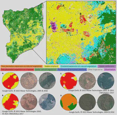
Comparing our maps with government cadastral records, ~40% of plantation expansion occurred on lands not legally designated for this land use. Relying on cadastral records only for assessing drivers & impacts of land use change (or LSLA), and policy impacts, can be misleading.

The maps are available online in Earth Engine, they also cover other land use/covers (cropland, natural forests, grasslands) in the four northernmost provinces of Mozambique over four time periods: Link to interactive map in Google Earth Engine
Patrick Meyfroidt
Professor of Land Systems and Sustainability Science
My research focuses on how land systems can contribute to sustainability.